


وصف لـ Mgrs & Utm Map
This application is GPS and coordinate systems helper especially for military personnel.
It is also a complete helper for mountaineering, trekking and hiking, cross running, scouting, hunting, fishing, geocaching, off-road navigation and all other outdoor activities and sports.
With satellite navigation systems such as GPS, GALILEO and GLONASS (GNSS) supported by your device and your sensors, you can see your most accurate position on different map layers.
Features:
* Easy and Faster
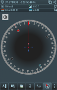
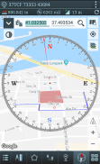
* Compass.
=> Compass on map (on the map that shows your direction)
=> Compass only (shows physical directions)
=> Angular units for compass (degrees and mil)
* Follow Mode
=> The center of the map follows your location while on the move.
* You can add and removing markers.
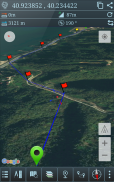
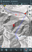
* Distance measure. (You can add custom route and calculate total distance)
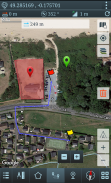
* Area measure.(You can select an area on the map and calculate the area in square meters)
* You can see the altitude of your location.
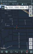
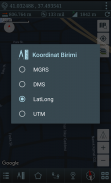
* You can find the location according to Degree/Minute/Second , MGRS, UTM or Latitude/Longitude formats.
* Location (Coordinate) format options.
=> MGRS / U.S. National Grid (USNG) (WGS84/NAD83)
=> D°M'S" (WGS84)
=> Latitude/Longitude (WGS84)
=> UTM (WGS84/NAD83)
=> SK42(Gauss Kruger)
* Map type options (Road,Terrain,Satellite,Night Mode,Hybrid)
* You can share location coordinate.
* Distance unit options. (meter and feet).
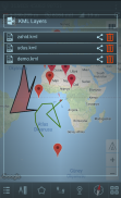
* KML viewer. (Export and import KML layers).
هذا التطبيق هو GPS وتنسيق أنظمة المساعد خاصة بالنسبة للأفراد العسكريين.
إنه أيضًا مساعد كامل لتسلق الجبال والرحلات والمشي لمسافات طويلة والركض المتجول والكشفية والصيد وصيد الأسماك ورياضة الجيوكاش والملاحة على الطرق الوعرة وجميع الأنشطة والرياضات الأخرى في الهواء الطلق.
مع أنظمة الملاحة عبر الأقمار الصناعية مثل GPS و GALILEO و GLONASS (GNSS) المدعومة من جهازك ومستشعراتك ، يمكنك رؤية موقعك الأكثر دقة على طبقات الخريطة المختلفة.
المميزات:
* سهل وأسرع
* بوصلة.
=> البوصلة على الخريطة (على الخريطة التي تبين اتجاهك)
=> البوصلة فقط (يظهر الاتجاهات المادية)
=> وحدات الزاوي للبوصلة (درجة وميل)
* اتبع الوضع
=> يتبع مركز الخريطة موقعك أثناء التنقل.
* يمكنك إضافة وإزالة علامات.
* قياس المسافة. (يمكنك إضافة مسار مخصص وحساب المسافة الإجمالية)
* قياس المساحة. (يمكنك اختيار منطقة على الخريطة وحساب المساحة بالمتر المربع)
* يمكنك أن ترى ارتفاع موقعك.
* يمكنك العثور على الموقع وفقًا لتنسيقات الدرجات / الدقائق / الثانية أو MGRS أو UTM أو Latitude / Longitude.
* خيارات تنسيق الموقع (تنسيق).
=> شبكة MGRS / الولايات المتحدة الوطنية (USNG) (WGS84 / NAD83)
=> D ° M'S "(WGS84)
=> خط الطول / الطول (WGS84)
=> UTM (WGS84 / NAD83)
=> SK42 (غاوس كروغر)
* خيارات نوع الخريطة (الطريق ، التضاريس ، الأقمار الصناعية ، الوضع الليلي ، الهجين)
* يمكنك مشاركة تنسيق الموقع.
* خيارات وحدة المسافة. (متر والقدمين).
* المشاهد KML. (تصدير واستيراد طبقات KML).
Mgrs & Utm Map - إصدار 7.2.5
(11-01-2024)
Mgrs & Utm Map - معلومات APK
نُسخة APK: 7.2.5الحزمة: com.zahidcataltas.mgrsharitaتطبيقات من الفئة نفسها
قد يعجبك أيضًا...


